Walking along the South Downs a few weeks back we stopped to talk to a man who was riding up to the top of the Downs on his bicycle. He was an artist and he mentioned that one of his places he loved was the Peaks. So here we are as a result of a simple conversation with a stranger on a walk. Our accomodation is at Goosehill Hall- it is a recently renovated listed 17th century small manor house in Castleton. The old farm buildings in the grounds of the Hall have been renovated to provide accomodation. Surrounded by fields and with views towards Mam Tor, the Great Ridge and Winnats Pass, and only a short walk from the village. What a nice little spot we have- the Gardeners cottage. Everything you would want.
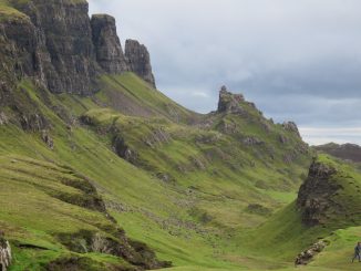
Thursday morning out we step from our place and start walking up the hills to the Limestone Way Path and via various ‘Bridle Ways and Public Footpaths’ we ended up at the top of Mam Tor. Mam Tor is a 517 m (1,696 ft) hill in the High Peak of Derbyshire. Its name means “mother hill”, so called because frequent landslips on its eastern face have resulted in a multitude of ‘mini-hills’ beneath it. These landslips, which are caused by unstable lower layers of shale, also give the hill its alternative name of Shivering Mountain. In 1979 the continual battle to maintain the A625 road (Sheffield to Chapel en le Frith) on the crumbling eastern side of the hill was lost when the road officially closed as a through-route. From the top here we walked along the ridge to Hollins Cross, Back Tor and Loosehill. I think we saw more people on this part of the walk than we have on any other walk we have done so far.- perhaps because it was sunny though realistically the views were everywhere to be seen. 14 kilometres later we were back in our abode. Not before however walking through Castleton and finding a nice little place for a coffee.


Friday morning we drove off to Lady Bower Dam to start our walk. Derwent is a village ‘drowned’ under the Ladybower Reservoir. The village of Ashopton, Derwent Woodlands church and Derwent Hall were also ‘drowned’ in the construction of the reservoir. There is no formal memorial to any of the villages. The church held its last service on 17 March 1943. Bodies from the graveyard had been exhumed in 1940 and were reburied in the village of Bamford.[3] All buildings in the village had been demolished by autumn 1943, and the impounded waters of the reservoir began to rise by the end of 1944. The church spire was left intact to form a memorial to Derwent. However, it was dynamited on 15 December 1947, on the rational of safety concerns. We walked along the banks of reservoir for a couple of miles, mainly in the forested area before heading sharply up through the forest to the top, at Jagger’s Clough. Here we followed an old Roman Road to Hope Brink which led us up to the top of Win Hill at 463m(1590 feet). The colours of the hills all around were purple due to Heather growing everywhere. We were told it was extremely good this year because of the weather conditions. We did not stay up here too long as we could here thunder see lightning in the distant. Descending through the Win Hill Plantation we stopped for lunch, but this was cut short as the rain started coming down. The rest of the walk down the Parkin Clough was wet and hazardous. A Clough is basically a riverbed coming down a mountain!!! This Clough was extremely steep and very slippery with the rain coming down it back home for a rest. For the first time since the first week of our holiday we went out to dinner. The Peak hotel pub- good pub food and a nice bottle of wine.


Be the first to comment